June 20
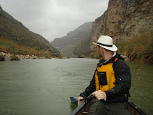
It was 6am and woke the sound of zippers and rustling from the tent next to me. Charmin was up, as usual, at the crack of dawn. She has come all the way from Switzerland to thruhike the PCT having never been to the US before- her visa expires in early October so she doesn't waste any time sleeping in, even on the coldest days. Today would be interesting. We had camped next to Tyndall Creek about 3 miles from Forester Pass the highest point on the PCT proper at about 13,500 feet high, but that wasn't the first challenge of the day, first we had to ford the creek. There's nothing like the thought of wading through icy roaring thigh high rapids first thing in the morning to make you want to leave your warm dry sleeping bag.
Charmin packed up and left a few moments before I did, it was cold and she needed to move. I left soon after and headed to the creek. It was lower than it was the evening before when I saw it, its all snow melt and it froze last night, but still I was going to get wet, I knew that much. After crossing I instantly lost the trail, it happens often here in the high sierra, but I have my own topo maps so I climb a small hill to get a better view. There are two possible valleys I could climb and I'm not sure which one is forester pass. I haven't seen Charmin for about 45 min now and I wonder if she made it across the creek. I stare at my maps and compass for another half hour.. crap, I need to make a decision. Everything is rock and ice, no visible trail, but if feel confident in my direction and head east about a mile across snow and scree before I find footprints. They are Charmin prints. Good, she's ahead. The climb up to the pass was solid ice and snow. Some steps had been kicked Into the crust from hikers before but they were sketchy at best and it was a long way down. I crested to pass sucking the thin air into my chest and scanned the valley southward. No one in sight, just huge mountains forever. On the other side of the pass there were 3 other hikers Noga and Shani the Israeli girls, and tortuga. I caught them on the glissade down and talked to them. "Charmin is way ahead, she saw your prints and is trying to catch you" they told me. Charmin was following the prints of someone else with my same shoes. Which we later found out was a group of 5 Kiwis all wearing keens. I pushed ahead to catch up. It wasn't long before the trail disappeared on the rocks again and about 2.5 miles after the pass I found myself alone and on some dangerous ice. When I lost the trail I had gone too far east in the valley and ended up at the top of a cliff 40 feet high. I scanned the rock for a route down and saw something that looked good so I went for it.10 feet down I realized that all the rocks were loose and the hold were covered in clear ice I chocked my ice axe into the rock for better purchase and slowly worked my way down to a rock ledge just above the base of the cliff. At the base I was not in the clear, there was a steep sheet of ice 800 ft down to the valley floor riddled with boulders. I perched on the ledge looking down at the ice and decided that I should strap crampons onto my feet. I knew right away that they wouldn't help much. 6 point trekking crampons are terrible on steep ice. I inched down carefully placing each foot. The ice was so hard that the spikes bearly bit and at one point my grip gave. I hit hard and slid fast knowing that the rocks were not far below. Wrenching into my stomach I threw all my weight onto my shoulder and pressed the pick of my axe as hard as I could into the ice. I was moving so fast that I wasn't sure if I would stop but the axe bit and I did. Whew, that was fun. The snow softened a bit and I glided down to level snow and found my feet again. I looked back up at the cliff and saw about 50 better routes down. Well now its obvious. I haven't seen trail in several hours now and here in the valley there is water everywhere. The trail is submerged. I reach for my trusty maps. They are gone. Lost somewhere up there on the high slopes where I fell. There's no way I would ever seem them again so I turned and pushed on without them. As I walked I ran through a mental inventory of my food, not much left, 2 days at best, I needed to get back on track. I knew the trail ran down this valley but I didn't know for how long. Soon I found Charmins boot tracks again and hauled to catch up. After 5 miles of watery muck, I saw her having lunch under a pine tree. She looked surprised to see me, thinking that I was ahead of her this whole time. I sat down, exhausted already at noon. "10 more miles to onion valley" she said. That's where we would be resupplying and maybe even getting a shower after 8 days out. "Awesome" I said. Yes, this word pretty much sums up the whole trail so far. Rock on.
Subscribe to:
Post Comments (Atom)

4 comments:
This is "Dirty Blonde" from AT 2007. We're following your adventure and living vicariously through you. We're planning a JMT hike for next summer.
**sending good trail vibes**
This is living On the Edge! Glad you made it down the ice face OK. What an adventure.
Ryan,
Love hearing about your trip. You got to use your ice axe!!! That's awesome in so many ways.
Take care and let us know if you need anything.
Aliese
holy crap, ice axe to the rescue!
Post a Comment